
Topografische kaart Upper Arlington
Interactieve kaart
Klik op de kaart om de hoogte weer te geven.
Over deze kaart
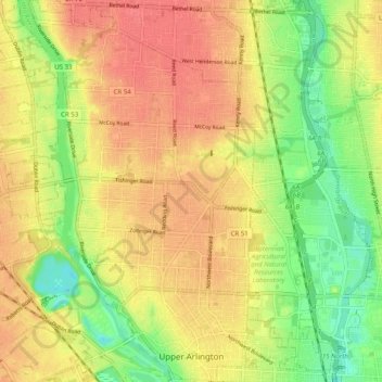
Naam: Topografische kaart Upper Arlington, hoogte, reliëf.
Gemiddelde hoogte: 249 m
Minimale hoogte: 211 m
Maximale hoogte: 279 m
The city is around 800 ft elevation located between the Olentangy and Scioto rivers. Two ravines cut through the city. The Slate Run in the northwest corner flows into the Scioto River. However, the Turkey Run is longer. It originates in the north then runs southwards until it makes an eastward bend around Reed Rd. Then, it flows eastwards through the OSU Golf Course. The run is used as a storm drain at points, has been dammed in the Ohio State course and runs through concrete pipes at two points. The soil is glacial till and is suitable for agriculture, supporting a research farm operated by The Ohio State University.