
Topografische kaart Opasquia Provincial Park
Interactieve kaart
Klik op de kaart om de hoogte weer te geven.
Over deze kaart
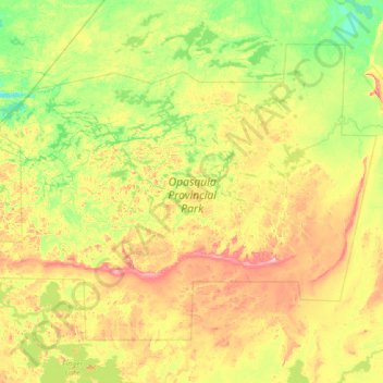
Naam: Topografische kaart Opasquia Provincial Park, hoogte, reliëf.
Gemiddelde hoogte: 282 m
Minimale hoogte: 225 m
Maximale hoogte: 407 m
Andere topografische kaarten
Klik op een kaart om zijn topografie, zijn hoogte en zijn reliëf te bekijken.
Sunday Lake
Canada > Ontario > Unorganized Kenora District
Sunday Lake, Highway 665, Unorganized Kenora District, Kenora District, Ontario, Canada
Gemiddelde hoogte: 399 m
Anishinabi Lake
Canada > Ontario > Unorganized Kenora District
Anishinabi Lake, Unorganized Kenora District, Kenora District, Ontario, Canada
Gemiddelde hoogte: 374 m
White Otter Lake
Canada > Ontario > Unorganized Kenora District
White Otter Lake, Unorganized Kenora District, Kenora District, Ontario, Canada
Gemiddelde hoogte: 439 m