
Topografische kaart The Municipal District of Athlone — Moate
Interactieve kaart
Klik op de kaart om de hoogte weer te geven.
Over deze kaart
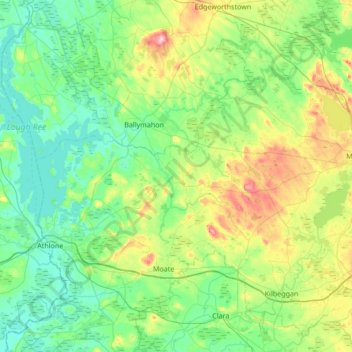
Naam: Topografische kaart The Municipal District of Athlone — Moate, hoogte, reliëf.
Gemiddelde hoogte: 69 m
Minimale hoogte: 30 m
Maximale hoogte: 197 m
Andere topografische kaarten
Klik op een kaart om zijn topografie, zijn hoogte en zijn reliëf te bekijken.
Aghafin
Aghafin, Noughaval ED, The Municipal District of Athlone — Moate, County Westmeath, Leinster, Ireland
Gemiddelde hoogte: 61 m
Castlelost
Castlelost, Castlelost ED, The Municipal District of Mullingar — Kinnegad, County Westmeath, Leinster, Ireland
Gemiddelde hoogte: 93 m
Calverstown
Calverstown, Clonfad ED, The Municipal District of Athlone — Moate, County Westmeath, Leinster, Ireland
Gemiddelde hoogte: 97 m
Ballygarvey
Ballygarvey, Glenlough ED, The Municipal District of Athlone — Moate, County Westmeath, Leinster, Ireland
Gemiddelde hoogte: 66 m
Rathnew
Rathnew, Ballymorin ED, The Municipal District of Athlone — Moate, County Westmeath, Leinster, Ireland
Gemiddelde hoogte: 134 m
Mullingar
Mullingar, The Municipal District of Mullingar — Kinnegad, County Westmeath, Leinster, Ireland
Gemiddelde hoogte: 99 m
Garrycastle
Ireland > County Westmeath > Garrycastle
Garrycastle, Athlone East Rural ED, The Municipal District of Athlone — Moate, County Westmeath, Leinster, Ireland
Gemiddelde hoogte: 49 m
Athlone
Ireland > County Westmeath > Athlone
Athlone, The Municipal District of Athlone — Moate, County Westmeath, Leinster, N37 N1F2, Ireland
Gemiddelde hoogte: 44 m
Mullingar
Ireland > County Westmeath > Mullingar
Mullingar, The Municipal District of Mullingar — Kinnegad, County Westmeath, Leinster, N91 FY58, Ireland
Gemiddelde hoogte: 101 m