
Topografische kaart Mount Kempt
Interactieve kaart
Klik op de kaart om de hoogte weer te geven.
Over deze kaart
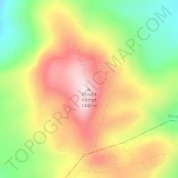
Naam: Topografische kaart Mount Kempt, hoogte, reliëf.
Gemiddelde hoogte: 1.166 m
Minimale hoogte: 905 m
Maximale hoogte: 1.419 m
Andere topografische kaarten
Klik op een kaart om zijn topografie, zijn hoogte en zijn reliëf te bekijken.
Great Kei River
RSA > Eastern Cape > Amahlathi Local Municipality
Great Kei River, Amahlathi Local Municipality, Amathole District Municipality, Eastern Cape, RSA
Gemiddelde hoogte: 620 m
Kubusi
RSA > Eastern Cape > Amahlathi Local Municipality
Kubusi, Amahlathi Local Municipality, Amathole District Municipality, Eastern Cape, RSA
Gemiddelde hoogte: 1.397 m
Waterdown Dam
RSA > Eastern Cape > Amahlathi Local Municipality
Waterdown Dam, R67, Amahlathi Ward 4, Amahlathi Local Municipality, Amathole District Municipality, Eastern Cape, RSA
Gemiddelde hoogte: 1.269 m