
Topografische kaart Cochrane
Interactieve kaart
Klik op de kaart om de hoogte weer te geven.
Cochrane
Until 1977, Timmins was used as the source for all weather readings attributed to Cochrane except for exceptional extremes, due to the overall similar climate due to proximity and topography. However, in December 1977, Cochrane temperature readings began to be taken from downtown after a noticeable difference in temperature was recorded two years prior in January 1976. However, to this day, if Cochrane's weather equipment fails at any time, the Timmins temperature readings are used due to the overall similarity.
Over deze kaart
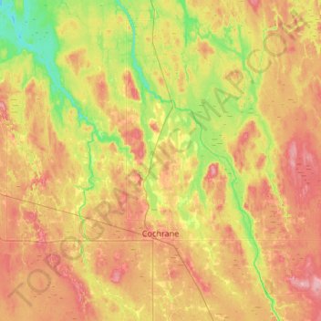
Naam: Topografische kaart Cochrane, hoogte, reliëf.
Gemiddelde hoogte: 262 m
Minimale hoogte: 216 m
Maximale hoogte: 311 m