
Topografische kaart Elbląg
Interactieve kaart
Klik op de kaart om de hoogte weer te geven.
Elbląg
The modern city adjoins about half the length of the river between Lake Drużno and Elbląg Bay (Zatoka Elbląska, an arm of the Vistula Lagoon), and spreads out on both banks, though mainly on the eastern side. To the east is the Elbląg Upland (Wysoczyzna Elbląska), a dome pushed up by glacial compression, 390 km2 in diameter and 200 m (656.17 ft) high at its greatest elevation. It gives the appearance of ridges and parkland.
Over deze kaart
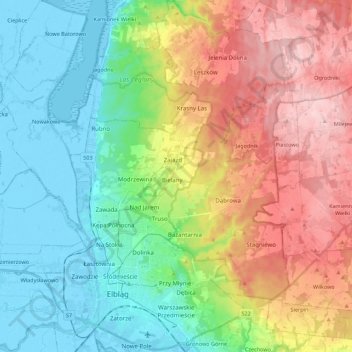
Naam: Topografische kaart Elbląg, hoogte, reliëf.
Locatie: Elbląg, Warmian-Masurian Voivodeship, Poland (54.13445 19.35901 54.26326 19.50969)
Gemiddelde hoogte: 75 m
Minimale hoogte: -6 m
Maximale hoogte: 197 m
Andere topografische kaarten
Klik op een kaart om zijn topografie, zijn hoogte en zijn reliëf te bekijken.
Masurian Lake District
Poland > Warmian-Masurian Voivodeship > Mrągowo County
Gemiddelde hoogte: 110 m
Rodowo
Poland > Warmian-Masurian Voivodeship > Mrągowo County > Jędrychowo > Rodowo
Gemiddelde hoogte: 162 m
Dylewska Góra
Poland > Warmian-Masurian Voivodeship > Ostróda County > Wysoka Wieś
Dylewska Góra (German: Kernsdorfer Höhe) is a hill located in northeastern Poland, south of the town of Ostróda, in the Warmian-Masurian Voivodeship. With elevation of 312 metres above sea level, it is one of the highest points of northern and central Poland. Dylewska Góra is a morainic hill, with its…
Gemiddelde hoogte: 269 m