
Topografische kaart Manapouri
Interactieve kaart
Klik op de kaart om de hoogte weer te geven.
Over deze kaart
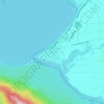
Naam: Topografische kaart Manapouri, hoogte, reliëf.
Gemiddelde hoogte: 213 m
Minimale hoogte: 176 m
Maximale hoogte: 539 m
Andere topografische kaarten
Klik op een kaart om zijn topografie, zijn hoogte en zijn reliëf te bekijken.
The Key
New Zealand > Southland > Southland District > Fiordland Community
The Key, Fiordland Community, Southland District, Southland, 9672, New Zealand
Gemiddelde hoogte: 325 m
Te Anau
New Zealand > Southland > Southland District > Fiordland Community
Te Anau, Fiordland Community, Southland District, Southland, 9600, New Zealand
Gemiddelde hoogte: 249 m
Milford Sound
New Zealand > Southland > Southland District > Fiordland Community
Milford Sound, Fiordland Community, Southland District, Southland, New Zealand
Gemiddelde hoogte: 304 m