
Topografische kaart Robie Creek
Interactieve kaart
Klik op de kaart om de hoogte weer te geven.
Over deze kaart
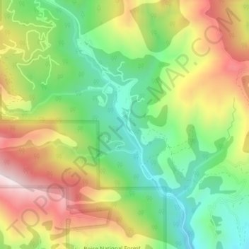
Naam: Topografische kaart Robie Creek, hoogte, reliëf.
Locatie: Robie Creek, Boise County, Idaho, United States of America (43.64933 -116.02892 43.65829 -116.02425)
Gemiddelde hoogte: 1.264 m
Minimale hoogte: 1.028 m
Maximale hoogte: 1.566 m
Andere topografische kaarten
Klik op een kaart om zijn topografie, zijn hoogte en zijn reliëf te bekijken.
Basalt
United States of America > Idaho > Basalt
Basalt, Bingham County, Idaho, 83218, United States of America
Gemiddelde hoogte: 1.398 m
Horse Ranch Mountain
United States of America > Idaho
Horse Ranch Mountain, Elmore County, Idaho, United States of America
Gemiddelde hoogte: 1.843 m
Coeur d'Alene River
United States of America > Idaho
Coeur d'Alene River, Kootenai County, Idaho, United States of America
Gemiddelde hoogte: 707 m
Nordman
United States of America > Idaho
Nordman, Bonner County, Idaho, 83848, United States of America
Gemiddelde hoogte: 831 m
Vernon Lake
United States of America > Idaho
Vernon Lake, Trail 482, Boise County, Idaho, United States of America
Gemiddelde hoogte: 2.686 m
Featherville
United States of America > Idaho > Featherville
Featherville, Elmore County, Idaho, United States of America
Gemiddelde hoogte: 1.513 m
Kendrick
United States of America > Idaho > Kendrick
Kendrick, Latah County, Idaho, 83537, United States of America
Gemiddelde hoogte: 559 m
Blackmare Lake
United States of America > Idaho
Blackmare Lake, Needles Route Pack Trail, Valley County, Idaho, United States of America
Gemiddelde hoogte: 2.298 m