
Topografische kaart Spaulding
Interactieve kaart
Klik op de kaart om de hoogte weer te geven.
Over deze kaart
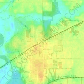
Naam: Topografische kaart Spaulding, hoogte, reliëf.
Locatie: Spaulding, Sangamon County, Illinois, United States (39.85809 -89.56385 39.87471 -89.52226)
Gemiddelde hoogte: 171 m
Minimale hoogte: 156 m
Maximale hoogte: 183 m
Andere topografische kaarten
Klik op een kaart om zijn topografie, zijn hoogte en zijn reliëf te bekijken.
Springfield
United States > Illinois > Sangamon County
Springfield, Sangamon County, Illinois, United States
Gemiddelde hoogte: 178 m
Williamsville
United States > Illinois > Sangamon County
Williamsville, Sangamon County, Illinois, 62693, United States
Gemiddelde hoogte: 177 m
Archer
United States > Illinois > Sangamon County > Springfield
Archer, Springfield, Sangamon County, Illinois, 62711, United States
Gemiddelde hoogte: 184 m
Pleasant Plains
United States > Illinois > Sangamon County
Pleasant Plains, Sangamon County, Illinois, United States
Gemiddelde hoogte: 187 m