
Topografische kaart Mangaluru
Interactieve kaart
Klik op de kaart om de hoogte weer te geven.
Over deze kaart
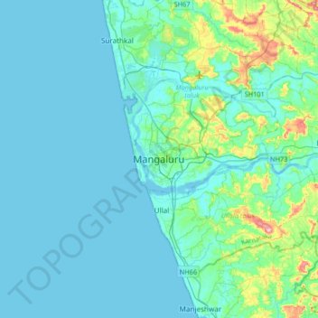
Naam: Topografische kaart Mangaluru, hoogte, reliëf.
Gemiddelde hoogte: 25 m
Minimale hoogte: -2 m
Maximale hoogte: 205 m
Mangalore is also the administrative headquarters of the Dakshina Kannada district; it is a commercial, industrial, educational, healthcare, and startup hub. The city's international airport is the second-largest and second-busiest airport in Karnataka. Mangalore City Corporation is responsible for the civic administration which manages the 60 wards of the city. Its landscape is characterised by rolling hills, coconut palms, rivers, and hard laterite soil. India's first 3D planetarium with 8K resolution display is located in the city. Mangalore is included as one of the cities in the Smart Cities Mission list and is among the 100 smart cities to be developed in India. It has an average elevation of 22 m (72 ft) above mean sea level. It has a tropical monsoon climate and is under the influence of the southwest monsoon. In 2017, Mangalore was ranked the 48th best city in the world to live in by a US survey, and the only Indian city in the top 50. It has its own International Airport which is around 15 km from the city.
Andere topografische kaarten
Klik op een kaart om zijn topografie, zijn hoogte en zijn reliëf te bekijken.
Kavoor
India > Karnataka > Mangaluru taluk
Kavoor, Mangaluru taluk, Dakshina Kannada District, Karnataka, 575015, India
Gemiddelde hoogte: 31 m
Kodikal
India > Karnataka > Mangaluru taluk
Kodikal, Mangaluru taluk, Dakshina Kannada District, Karnataka, 575006, India
Gemiddelde hoogte: 17 m
Tanniru Bavi
India > Karnataka > Mangaluru taluk
Tanniru Bavi, Mangaluru taluk, Dakshina Kannada District, Karnataka, 575006, India
Gemiddelde hoogte: 8 m
Vamanjoor
India > Karnataka > Mangaluru taluk
Vamanjoor, Mangaluru taluk, Dakshina Kannada district, Karnataka, 575005, India
Gemiddelde hoogte: 56 m
Kuloor
India > Karnataka > Mangaluru taluk
Kuloor, Mangaluru taluk, Dakshina Kannada district, Karnataka, 575010, India
Gemiddelde hoogte: 12 m
Kenjar
India > Karnataka > Mangaluru taluk > Kenjar
Kenjar, Mangaluru taluk, Dakshina Kannada district, Karnataka, 575015, India
Gemiddelde hoogte: 27 m
Bhatrakere
India > Karnataka > Mangaluru taluk > Bhatrakere
Bhatrakere, Mangaluru taluk, Dakshina Kannada district, Karnataka, 574509, India
Gemiddelde hoogte: 66 m