
Topografische kaart Summerville
Interactieve kaart
Klik op de kaart om de hoogte weer te geven.
Over deze kaart
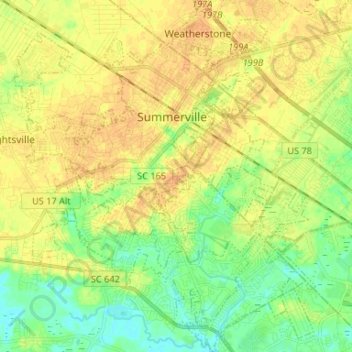
Naam: Topografische kaart Summerville, hoogte, reliëf.
Gemiddelde hoogte: 17 m
Minimale hoogte: 3 m
Maximale hoogte: 29 m
Andere topografische kaarten
Klik op een kaart om zijn topografie, zijn hoogte en zijn reliëf te bekijken.
Ridgeville
United States > South Carolina > Dorchester County
Ridgeville, Dorchester County, South Carolina, United States
Gemiddelde hoogte: 18 m
Warington
United States > South Carolina > Dorchester County > Summerville
Warington, Summerville, Dorchester County, South Carolina, 29483, United States
Gemiddelde hoogte: 23 m
Stallsville
United States > South Carolina > Dorchester County > Summerville
Stallsville, Summerville, Dorchester County, South Carolina, 39485, United States
Gemiddelde hoogte: 19 m
Flowertown Village
United States > South Carolina > Dorchester County
Flowertown Village, Dorchester County, South Carolina, United States
Gemiddelde hoogte: 20 m