
Topografische kaart Marble Hill
Interactieve kaart
Klik op de kaart om de hoogte weer te geven.
Over deze kaart
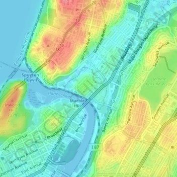
Naam: Topografische kaart Marble Hill, hoogte, reliëf.
Locatie: Marble Hill, New York, United States of America (40.87140 -73.91838 40.88045 -73.90616)
Gemiddelde hoogte: 27 m
Minimale hoogte: 0 m
Maximale hoogte: 75 m
Because of this change in topography, Marble Hill is often associated with the Bronx and is part of Bronx Community District 8. In addition, Marble Hill has a Bronx ZIP Code of 10463, and is served by the New York City Police Department's 50th Precinct, headquartered in the Bronx.
Andere topografische kaarten
Klik op een kaart om zijn topografie, zijn hoogte en zijn reliëf te bekijken.
Wave Hill
United States of America > New York > New York
Wave Hill, Riverdale, New York, The Bronx, Bronx County, New York, United States of America
Gemiddelde hoogte: 25 m
WNYC-AM (New York)
United States of America > New York > New York
WNYC-AM (New York), 8, Greenpoint Avenue, Greenpoint, New York, Brooklyn, Kings County, New York, 11222, United States of America
Gemiddelde hoogte: 4 m
Liggett Terrace
United States of America > New York > New York > Liggett Terrace
Liggett Terrace, Manhattan Community Board 1, Manhattan, New York County, New York, 10004, United States of America
Gemiddelde hoogte: 3 m