
Topografische kaart Wenatchee
Klik op de kaart om de hoogte weer te geven.
Wenatchee
Wenatchee is characterized by its diverse topography, nestled at an average elevation of approximately 800 feet. The city is situated in a valley surrounded by significant geographical features, including the rugged foothills of the Cascade Mountains, which rise sharply to elevations of over 4,500 feet just to the west. The terrain includes a blend of rolling hills and steep cliffs, with the Columbia River cutting through the area, providing a stark contrast between the flat valley floor and the towering ridges that define the landscape. This topographical variation creates a unique environment that supports a mix of ecosystems, from arid shrublands to lush forests at higher elevations.
Over deze kaart
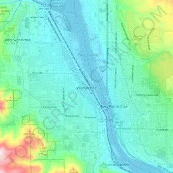
Naam: Topografische kaart Wenatchee, hoogte, reliëf.
Locatie: Wenatchee, Chelan County, Washington, United States (47.38749 -120.36772 47.46056 -120.29281)
Gemiddelde hoogte: 302 m
Minimale hoogte: 184 m
Maximale hoogte: 807 m
Andere topografische kaarten
Klik op een kaart om zijn topografie, zijn hoogte en zijn reliëf te bekijken.
Mount Stuart
United States > Washington > Chelan County
Mount Stuart is more notable for its local relief than for its absolute elevation. For example, the south face rises 5,000 feet (1,500 m) in just 2 horizontal miles (3.2 km). The northeast and northwest sides of the mountain exhibit similar steep relief. Due to its location away from higher peaks, Mount Stuart…
Gemiddelde hoogte: 2.109 m
Dragontail Peak
United States > Washington > Chelan County
The Alpine Lakes Wilderness features some of the most rugged topography in the Cascade Range with craggy peaks and ridges, deep glacial valleys, and granite walls spotted with over 700 mountain lakes. Geological events occurring many years ago created the diverse topography and drastic elevation changes over…
Gemiddelde hoogte: 2.235 m