
Topografische kaart Wejherowo
Interactieve kaart
Klik op de kaart om de hoogte weer te geven.
Over deze kaart
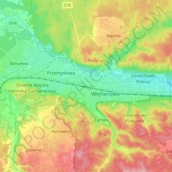
Naam: Topografische kaart Wejherowo, hoogte, reliëf.
Locatie: Wejherowo, Wejherowo County, Pomeranian Voivodeship, Poland (54.57808 18.16262 54.63410 18.30463)
Gemiddelde hoogte: 71 m
Minimale hoogte: 5 m
Maximale hoogte: 158 m
Wejherowo is located in Pomeralia, in the ethnocultural region of Kashubia, approximately 11 km (7 mi) west of the town of Rumia, 32 kilometres (20 miles) east of the town of Lębork and 35 km (22 mi) north-west of the regional metropole of Gdańsk, in the broad glacial valley of the river Rheda at an altitude of 30 metres (98 feet) above sea level.