
Topografische kaart Leesburg
Interactieve kaart
Klik op de kaart om de hoogte weer te geven.
Over deze kaart
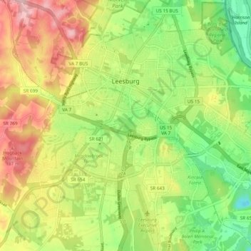
Naam: Topografische kaart Leesburg, hoogte, reliëf.
Locatie: Leesburg, Loudoun County, Virginia, United States (39.06762 -77.60243 39.13853 -77.50793)
Gemiddelde hoogte: 113 m
Minimale hoogte: 32 m
Maximale hoogte: 215 m
Leesburg is located northeast of the center of Loudoun County at 39°7′N 77°33′W / 39.117°N 77.550°W / 39.117; -77.550 (39.109, −77.558), It is part of the northern Virginia Piedmont and sits at the base of the easternmost chain of the Blue Ridge Mountains, Catoctin Mountain. The town lies in the Culpeper Basin (an inland sea during the Jurassic period) and is adjacent to the valley of the Potomac River, so that the local relief is less pronounced than in other Virginia Piedmont towns. Elevation in town ranges from about 350 to 400 feet (110 to 120 m), with the ridge of Catoctin Mountain rising to 670 feet (200 m) just west of the town limits. The Town Branch of Tuscarora Creek passes through the center of town, flowing east to Goose Creek, a tributary of the Potomac.
Andere topografische kaarten
Klik op een kaart om zijn topografie, zijn hoogte en zijn reliëf te bekijken.
Aldie
United States > Virginia > Loudoun County
Aldie, Loudoun County, Virginia, United States
Gemiddelde hoogte: 119 m
South Riding
United States > Virginia > Loudoun County
South Riding, Loudoun County, Virginia, 20152, United States
Gemiddelde hoogte: 93 m
Ashburn
United States > Virginia > Loudoun County > Ashburn
Ashburn, Loudoun County, Virginia, United States
Gemiddelde hoogte: 85 m
Cascades
United States > Virginia > Loudoun County
Cascades, Loudoun County, Virginia, 20165, United States
Gemiddelde hoogte: 81 m
Trapp
United States > Virginia > Loudoun County
Trapp, Loudoun County, Virginia, 20135, United States
Gemiddelde hoogte: 286 m