
Topografische kaart Udaipur
Interactieve kaart
Klik op de kaart om de hoogte weer te geven.
Over deze kaart
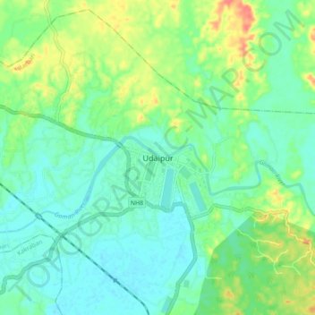
Naam: Topografische kaart Udaipur, hoogte, reliëf.
Locatie: Udaipur, Matarbari, Gomati, Tripura, 799120, India (23.50162 91.45176 23.58162 91.53176)
Gemiddelde hoogte: 33 m
Minimale hoogte: 16 m
Maximale hoogte: 70 m
Udaipur is located at 23°32′N 91°29′E / 23.53°N 91.48°E / 23.53; 91.48. It has an average elevation of 22 metres (72 feet).The Gomati river passes through the heart of Udaipur and helps in irrigation of its lands.