
Topografische kaart Tongass National Forest
Interactieve kaart
Klik op de kaart om de hoogte weer te geven.
Over deze kaart
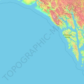
Naam: Topografische kaart Tongass National Forest, hoogte, reliëf.
Gemiddelde hoogte: 156 m
Minimale hoogte: -4 m
Maximale hoogte: 4.094 m
Historically, logging operations tended to concentrate on lower-elevation, bigger-tree ecosystems for harvesting; at present, approximately 78% of the land remains intact, i.e. 383,000 acres (1,550 km2) out of 491,000 acres (1,990 km2) original big-tree, low-elevation forest area. Given the high value of these areas for wildlife species, close to 70% of this old growth forest is protected in reserves and will never be eligible for harvest.
Andere topografische kaarten
Klik op een kaart om zijn topografie, zijn hoogte en zijn reliëf te bekijken.
Clarence Kramer Peak
United States > Alaska > Sitka > Sitka
Clarence Kramer Peak, Sitka, Alaska, United States
Gemiddelde hoogte: 751 m
North Sister
United States > Alaska > Sitka > Sitka
North Sister, Sitka, Alaska, United States
Gemiddelde hoogte: 507 m
Beaver Lake
United States > Alaska > Sitka > Sitka
Beaver Lake, Sitka, Alaska, United States
Gemiddelde hoogte: 313 m
Fleming Island
United States > Alaska > Sitka
Fleming Island, Sitka, Alaska, United States
Gemiddelde hoogte: 149 m
Mount Edgecumbe
United States > Alaska > Sitka
Mount Edgecumbe, Sitka, Alaska, United States
Gemiddelde hoogte: 597 m