
Topografische kaart Gundagai
Interactieve kaart
Klik op de kaart om de hoogte weer te geven.
Over deze kaart
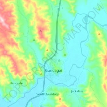
Naam: Topografische kaart Gundagai, hoogte, reliëf.
Gemiddelde hoogte: 309 m
Minimale hoogte: 208 m
Maximale hoogte: 622 m
Gundagai is an inland town with an elevation of 250 metres (820 ft). Almost all of the shire is located in the South West Slopes bio-region and is part of the Riverina agricultural region. The eastern part of the shire is considered part of the South Eastern Highlands bioregion.