
Topografische kaart Tzintzuntzan
Interactieve kaart
Klik op de kaart om de hoogte weer te geven.
Over deze kaart
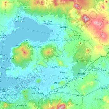
Naam: Topografische kaart Tzintzuntzan, hoogte, reliëf.
Locatie: Tzintzuntzan, Michoacán de Ocampo, México (19.55917 -101.65280 19.66251 -101.42938)
Gemiddelde hoogte: 2.201 m
Minimale hoogte: 2.034 m
Maximale hoogte: 2.849 m