
Topografische kaart Hartell
Interactieve kaart
Klik op de kaart om de hoogte weer te geven.
Over deze kaart
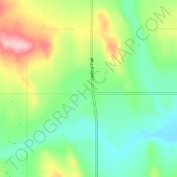
Naam: Topografische kaart Hartell, hoogte, reliëf.
Locatie: Hartell, Foothills County, Alberta, Canada (50.58220 -114.25381 50.62220 -114.21381)
Gemiddelde hoogte: 1.266 m
Minimale hoogte: 1.199 m
Maximale hoogte: 1.396 m
Andere topografische kaarten
Klik op een kaart om zijn topografie, zijn hoogte en zijn reliëf te bekijken.
Brown-Lowery Provincial Park
Canada > Alberta > Foothills County
Brown-Lowery Provincial Park, Foothills County, Alberta, Canada
Gemiddelde hoogte: 1.353 m
Aldersyde
Canada > Alberta > Foothills County
Aldersyde, Foothills County, Alberta, T0L 1T0, Canada
Gemiddelde hoogte: 1.046 m
Sheep River
Canada > Alberta > Foothills County
Sheep River, Foothills County, Alberta, Canada
Gemiddelde hoogte: 1.426 m
Priddis
Canada > Alberta > Foothills County
Priddis, Foothills County, Alberta, Canada
Gemiddelde hoogte: 1.193 m
Millarville
Canada > Alberta > Foothills County
Millarville, Foothills County, Alberta, T0L 1K0, Canada
Gemiddelde hoogte: 1.220 m
Sheep River
Canada > Alberta > Foothills County
Sheep River, Foothills County, Alberta, T0L 2O0, Canada
Gemiddelde hoogte: 1.358 m
Highwood River
Canada > Alberta > Foothills County > Village of Longview
Highwood River, Village of Longview, Foothills County, Alberta, T0L 1H0, Canada
Gemiddelde hoogte: 1.232 m
De Winton
Canada > Alberta > Foothills County
De Winton, Foothills County, Alberta, T2V 3Z4, Canada
Gemiddelde hoogte: 1.104 m
Cayley
Canada > Alberta > Foothills County
Cayley, Foothills County, Alberta, Canada
Gemiddelde hoogte: 1.070 m