
Topografische kaart Boone
Interactieve kaart
Klik op de kaart om de hoogte weer te geven.
Over deze kaart
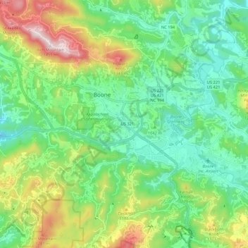
Naam: Topografische kaart Boone, hoogte, reliëf.
Locatie: Boone, Watauga County, North Carolina, United States (36.18724 -81.71540 36.23029 -81.61023)
Gemiddelde hoogte: 1.068 m
Minimale hoogte: 890 m
Maximale hoogte: 1.437 m
Boone is located at 36°12′41″N 81°40′7″W / 36.21139°N 81.66861°W / 36.21139; -81.66861 (36.211364, −81.668657) and has an elevation of 3,333 feet (1015.9 m) above sea level. An earlier survey gave the elevation as 3,332 ft and since then it has been published as having an elevation of 3,333 ft (1,016 m). Boone has the highest elevation of any town of its size (over 10,000 population) east of the Mississippi River. As such, Boone features, depending on the isotherm used, a humid continental climate (Köppen Dfb), a rarity for the Southeastern United States, bordering on a subtropical highland climate (Cfb) and straddles the boundary between USDA Plant Hardiness Zones 6B and 7A; the elevation also results in enhanced precipitation, with 59.13 inches (1,500 mm) of average annual precipitation. Compared to the lower elevations of the Carolinas, winters are long and cold, with frequent sleet and snowfall. The daily average temperature in January is 31.5 °F (−0.3 °C), which gives Boone a winter climate more similar to coastal southern New England rather than the Southeast, where a humid subtropical climate (Cfa) predominates. Blizzard-like conditions are not unusual during many winters. Summers are warm, but far cooler and less humid than lower regions to the south and east, with a July daily average temperature of 68.4 °F (20.2 °C). Boone typically receives on average nearly 25 inches (64 cm) of snowfall annually, far higher than the lowland areas in the rest of North Carolina. On January 21, 1985, the temperature fell to −24 °F (−31 °C).
Andere topografische kaarten
Klik op een kaart om zijn topografie, zijn hoogte en zijn reliëf te bekijken.
Blue Ridge Parkway
United States > North Carolina > Watauga County
Blue Ridge Parkway, Watauga County, North Carolina, United States
Gemiddelde hoogte: 505 m
Meat Camp
United States > North Carolina > Watauga County
Meat Camp, Watauga County, North Carolina, United States
Gemiddelde hoogte: 1.166 m
Foscoe
United States > North Carolina > Watauga County
Foscoe, Watauga County, North Carolina, United States
Gemiddelde hoogte: 998 m
Sugar Grove
United States > North Carolina > Watauga County
Sugar Grove, Watauga County, North Carolina, 28692, United States
Gemiddelde hoogte: 895 m
Moses H Cone Memorial Park
United States > North Carolina > Watauga County > Blowing Rock
Moses H Cone Memorial Park, Blowing Rock, Watauga County, North Carolina, 28605, United States
Gemiddelde hoogte: 1.121 m
Seven Devils
United States > North Carolina > Watauga County
Seven Devils, Watauga County, North Carolina, United States
Gemiddelde hoogte: 1.175 m
Triplett
United States > North Carolina > Watauga County
Triplett, Watauga County, North Carolina, 28618, United States
Gemiddelde hoogte: 718 m
Zionville
United States > North Carolina > Watauga County > Zionville
Zionville, Watauga County, North Carolina, 27691, United States
Gemiddelde hoogte: 1.060 m
Vilas
United States > North Carolina > Watauga County
Vilas, Watauga County, North Carolina, 28692, United States
Gemiddelde hoogte: 898 m
Moretz
United States > North Carolina > Watauga County > Moretz
Moretz, Watauga County, North Carolina, United States
Gemiddelde hoogte: 989 m
Boone
United States > North Carolina > Watauga County > Boone > Boone
Boone, Watauga County, North Carolina, 28607-1017, United States
Gemiddelde hoogte: 977 m
Sorrento Skies
United States > North Carolina > Watauga County > Sorrento Skies
Sorrento Skies, Watauga County, North Carolina, 28607-1000, United States
Gemiddelde hoogte: 1.069 m
Blowing Rock
United States > North Carolina > Watauga County
Blowing Rock, Watauga County, North Carolina, 28605, United States
Gemiddelde hoogte: 1.032 m
Kelsey
United States > North Carolina > Watauga County > Kelsey
Kelsey, Watauga County, North Carolina, 28605, United States
Gemiddelde hoogte: 978 m
Rominger
United States > North Carolina > Watauga County > Rominger
Rominger, Watauga County, North Carolina, 28679, United States
Gemiddelde hoogte: 1.068 m
Beech Mountain
United States > North Carolina > Watauga County > Beech Mountain
Beech Mountain, Watauga County, North Carolina, United States
Gemiddelde hoogte: 1.264 m
Beech Mountain
United States > North Carolina > Watauga County
Beech Mountain, Watauga County, North Carolina, United States
Gemiddelde hoogte: 1.267 m