
Topografische kaart Bukowina Tatrzańska
Interactieve kaart
Klik op de kaart om de hoogte weer te geven.
Over deze kaart
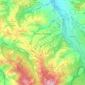
Naam: Topografische kaart Bukowina Tatrzańska, hoogte, reliëf.
Gemiddelde hoogte: 886 m
Minimale hoogte: 718 m
Maximale hoogte: 1.147 m
Andere topografische kaarten
Klik op een kaart om zijn topografie, zijn hoogte en zijn reliëf te bekijken.
Zakopane
Poland > Lesser Poland Voivodeship > Tatra County
Zakopane, Tatra County, Lesser Poland Voivodeship, Poland
Gemiddelde hoogte: 1.180 m
Wielki Giewont
Poland > Lesser Poland Voivodeship > Tatra County > Zakopane
Wielki Giewont, Zakopane, Tatra County, Lesser Poland Voivodeship, Poland
Gemiddelde hoogte: 1.478 m
Sarnia Skała
Poland > Lesser Poland Voivodeship > Tatra County > Zakopane
Sarnia Skała, Zakopane, Tatra County, Lesser Poland Voivodeship, 34-500, Poland
Gemiddelde hoogte: 1.206 m
Tatry
Poland > Lesser Poland Voivodeship > Tatra County > Zakopane
Tatry, Zakopane, Tatra County, Lesser Poland Voivodeship, Poland
Gemiddelde hoogte: 1.647 m
Zakopane
Poland > Lesser Poland Voivodeship > Tatra County
Zakopane, Tatra County, Lesser Poland Voivodeship, Poland
Gemiddelde hoogte: 1.180 m