
Topografische kaart Wanlip
Interactieve kaart
Klik op de kaart om de hoogte weer te geven.
Over deze kaart
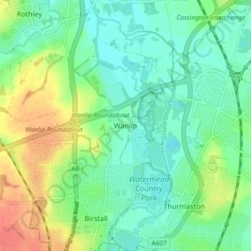
Naam: Topografische kaart Wanlip, hoogte, reliëf.
Gemiddelde hoogte: 61 m
Minimale hoogte: 43 m
Maximale hoogte: 96 m
Andere topografische kaarten
Klik op een kaart om zijn topografie, zijn hoogte en zijn reliëf te bekijken.
Mammoth Lake
United Kingdom > England > Leicestershire > Borough of Charnwood > Thurmaston
Mammoth Lake, Thurmaston, Borough of Charnwood, Leicestershire, England, United Kingdom
Gemiddelde hoogte: 58 m
Barkby Thorpe
United Kingdom > England > Leicestershire > Borough of Charnwood
Barkby Thorpe, Borough of Charnwood, Leicestershire, England, United Kingdom
Gemiddelde hoogte: 89 m
Charnwood Forest Canal (Disused)
United Kingdom > England > Leicestershire > Borough of Charnwood > Nanpantan
Charnwood Forest Canal (Disused), Nanpantan, Borough of Charnwood, Leicestershire, England, LE11 3YA, United Kingdom
Gemiddelde hoogte: 98 m
Anstey
United Kingdom > England > Leicestershire > Borough of Charnwood
Anstey, Borough of Charnwood, Leicestershire, England, United Kingdom
Gemiddelde hoogte: 84 m
Ratcliffe on the Wreake
United Kingdom > England > Leicestershire > Borough of Charnwood
Ratcliffe on the Wreake, Borough of Charnwood, Leicestershire, England, LE7 4SN, United Kingdom
Gemiddelde hoogte: 68 m
Thurcaston
United Kingdom > England > Leicestershire > Borough of Charnwood
Thurcaston, Borough of Charnwood, Leicestershire, England, LE7 7JP, United Kingdom
Gemiddelde hoogte: 73 m
Seagrave
United Kingdom > England > Leicestershire > Borough of Charnwood
Seagrave, Borough of Charnwood, Leicestershire, England, LE12 7NL, United Kingdom
Gemiddelde hoogte: 92 m