
Topografische kaart Maricopa
Interactieve kaart
Klik op de kaart om de hoogte weer te geven.
Over deze kaart
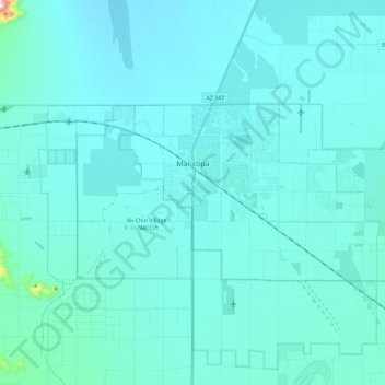
Naam: Topografische kaart Maricopa, hoogte, reliëf.
Locatie: Maricopa, Pinal County, Arizona, United States (32.99913 -112.15078 33.08794 -111.92039)
Gemiddelde hoogte: 369 m
Minimale hoogte: 334 m
Maximale hoogte: 872 m
The topography in Maricopa is flat, with several mountain ranges 10 to 20 miles away. The elevation of Maricopa is 1190 feet.
Andere topografische kaarten
Klik op een kaart om zijn topografie, zijn hoogte en zijn reliëf te bekijken.
Kelvin
United States > Arizona > Pinal County
Kelvin, Pinal County, Arizona, 85137, United States
Gemiddelde hoogte: 626 m
Eloy
United States > Arizona > Pinal County
Eloy, Pinal County, Arizona, United States
Gemiddelde hoogte: 478 m
Gold Canyon
United States > Arizona > Pinal County > Apache Junction
Gold Canyon, Apache Junction, Pinal County, Arizona, 85218, United States
Gemiddelde hoogte: 675 m
Heaton
United States > Arizona > Pinal County > Maricopa
Heaton, Maricopa, Pinal County, Arizona, United States
Gemiddelde hoogte: 367 m
Apache Junction
United States > Arizona > Pinal County
Apache Junction, Pinal County, Arizona, United States
Gemiddelde hoogte: 504 m
Coolidge
United States > Arizona > Pinal County
Coolidge, Pinal County, Arizona, United States
Gemiddelde hoogte: 439 m
Mammoth
United States > Arizona > Pinal County
Mammoth, Pinal County, Arizona, 85618, United States
Gemiddelde hoogte: 756 m
Florence
United States > Arizona > Pinal County
Florence, Pinal County, Arizona, 85132, United States
Gemiddelde hoogte: 484 m
Casa Grande
United States > Arizona > Pinal County
Casa Grande, Pinal County, Arizona, United States
Gemiddelde hoogte: 437 m