
Topografische kaart Abilene
Interactieve kaart
Klik op de kaart om de hoogte weer te geven.
Over deze kaart
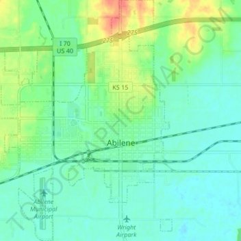
Naam: Topografische kaart Abilene, hoogte, reliëf.
Locatie: Abilene, Dickinson County, Kansas, United States (38.89601 -97.26351 38.94806 -97.19962)
Gemiddelde hoogte: 357 m
Minimale hoogte: 343 m
Maximale hoogte: 390 m
Abilene is at 38°55′11″N 97°13′2″W / 38.91972°N 97.21722°W / 38.91972; -97.21722 (38.919721, −97.217329) at an elevation of 1,155 feet (352 m). The city is on the north side of the Smoky Hill River in the Flint Hills region of the Great Plains. Mud Creek, a tributary of the Smoky Hill, flows south through the city. Located in North Central Kansas at the intersection of Interstate 70 and K-15, Abilene is approximately 27 mi (43 km) east of Salina, Kansas, 94 mi (151 km) north of Wichita, and 139 mi (224 km) west of Kansas City.
Andere topografische kaarten
Klik op een kaart om zijn topografie, zijn hoogte en zijn reliëf te bekijken.
Enterprise
United States > Kansas > Dickinson County
Enterprise, Dickinson County, Kansas, United States
Gemiddelde hoogte: 354 m
Chapman
United States > Kansas > Dickinson County
Chapman, Dickinson County, Kansas, 67431, United States
Gemiddelde hoogte: 349 m
Herington
United States > Kansas > Dickinson County
Herington, Dickinson County, Kansas, United States
Gemiddelde hoogte: 415 m
Talmage
United States > Kansas > Dickinson County
Talmage, Dickinson County, Kansas, 67482, United States
Gemiddelde hoogte: 380 m
Solomon
United States > Kansas > Dickinson County
Solomon, Dickinson County, Kansas, United States
Gemiddelde hoogte: 364 m