
Doe een donatie
Rust jezelf uit voor je volgende avontuur:
Als Amazon-partner verdient deze site een commissie op in aanmerking komende aankopen, zonder extra kosten voor jou.
Topografische kaart Meander River
Klik op de kaart om de hoogte weer te geven.
Doe een donatie
Rust jezelf uit voor je volgende avontuur:
Als Amazon-partner verdient deze site een commissie op in aanmerking komende aankopen, zonder extra kosten voor jou.
Meander River
The settlement is located on the banks of the Hay River, at an elevation of 328 meters (1,076 ft). The plant hardiness zone of Meander River is 0B, the second lowest possible within Canada, due primarily to its northern latitude.
Doe een donatie
Rust jezelf uit voor je volgende avontuur:
Als Amazon-partner verdient deze site een commissie op in aanmerking komende aankopen, zonder extra kosten voor jou.
Over deze kaart
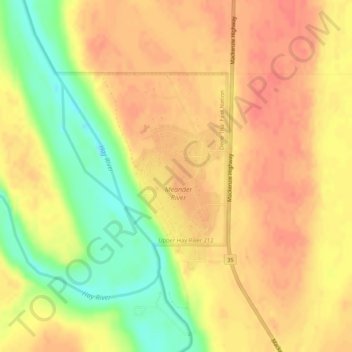
Naam: Topografische kaart Meander River, hoogte, reliëf.
Locatie: Meander River, Mackenzie County, Alberta, Canada (59.03497 -117.72398 59.05497 -117.70398)
Gemiddelde hoogte: 325 m
Minimale hoogte: 292 m
Maximale hoogte: 341 m
Doe een donatie
Rust jezelf uit voor je volgende avontuur:
Als Amazon-partner verdient deze site een commissie op in aanmerking komende aankopen, zonder extra kosten voor jou.