
Topografische kaart Three Sisters
Interactieve kaart
Klik op de kaart om de hoogte weer te geven.
Over deze kaart
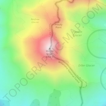
Naam: Topografische kaart Three Sisters, hoogte, reliëf.
Locatie: Three Sisters, Deschutes County, Oregon, United States (44.14716 -121.78299 44.14726 -121.78289)
Gemiddelde hoogte: 2.526 m
Minimale hoogte: 2.164 m
Maximale hoogte: 3.046 m
The Three Sisters are closely spaced volcanic peaks in the U.S. state of Oregon. They are part of the Cascade Volcanic Arc, a segment of the Cascade Range in western North America extending from southern British Columbia through Washington and Oregon to Northern California. Each more than 10,000 feet (3,000 m) in elevation, they are the third-, fourth- and fifth-highest peaks in Oregon. Located in the Three Sisters Wilderness at the boundary of Lane and Deschutes counties and the Willamette and Deschutes national forests, they are about 10 miles (16 km) south of the nearest town, Sisters. Diverse species of flora and fauna inhabit the area, which is subject to frequent snowfall, occasional rain, and extreme temperature variation between seasons. The mountains, particularly South Sister, are popular destinations for climbing and scrambling.
Andere topografische kaarten
Klik op een kaart om zijn topografie, zijn hoogte en zijn reliëf te bekijken.
Bend
United States > Oregon > Deschutes County
Bend, Deschutes County, Oregon, United States
Gemiddelde hoogte: 1.121 m