
Topografische kaart Ellicott City
Interactieve kaart
Klik op de kaart om de hoogte weer te geven.
Over deze kaart
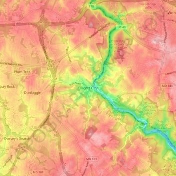
Naam: Topografische kaart Ellicott City, hoogte, reliëf.
Locatie: Ellicott City, Howard County, Maryland, 21043, United States (39.22733 -76.83831 39.30733 -76.75831)
Gemiddelde hoogte: 119 m
Minimale hoogte: 16 m
Maximale hoogte: 170 m
Andere topografische kaarten
Klik op een kaart om zijn topografie, zijn hoogte en zijn reliëf te bekijken.
Patapsco Valley State Park
United States > Maryland > Howard County > Ilchester
Patapsco Valley State Park, Ilchester, Howard County, Maryland, 21163, United States
Gemiddelde hoogte: 131 m
Centennial Lake
United States > Maryland > Howard County
Centennial Lake, Dorsey's Search, Howard County, Maryland, United States
Gemiddelde hoogte: 116 m
Elkridge
United States > Maryland > Howard County
Elkridge, Howard County, Maryland, 21075, United States
Gemiddelde hoogte: 39 m
Hanover
United States > Maryland > Howard County
Hanover, Howard County, Maryland, 21076, United States
Gemiddelde hoogte: 42 m
Marriottsville
United States > Maryland > Howard County
Marriottsville, Howard County, Maryland, 21104, United States
Gemiddelde hoogte: 130 m
Waterloo
United States > Maryland > Howard County
Waterloo, Howard County, Maryland, 20794, United States
Gemiddelde hoogte: 75 m
Clarksville
United States > Maryland > Howard County
Clarksville, Howard County, Maryland, 21029, United States
Gemiddelde hoogte: 134 m
Ellicott City
United States > Maryland > Howard County > Ellicott City
Ellicott City, Howard County, Maryland, United States
Gemiddelde hoogte: 123 m
Columbia
United States > Maryland > Howard County > Columbia
Columbia, Howard County, Maryland, United States
Gemiddelde hoogte: 114 m