
Topografische kaart Chinon
Interactieve kaart
Klik op de kaart om de hoogte weer te geven.
Over deze kaart
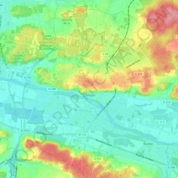
Naam: Topografische kaart Chinon, hoogte, reliëf.
Gemiddelde hoogte: 58 m
Minimale hoogte: 24 m
Maximale hoogte: 124 m
Topography has played a major role: the formerly fortified town was developed at the foot of the castle on the rocky outcrop, protecting the northern side, with the Vienne River in the south. Apart from the natural defensive protection on both sides, this fact makes a long narrow urban space, with the main streets running parallel to the river.
Andere topografische kaarten
Klik op een kaart om zijn topografie, zijn hoogte en zijn reliëf te bekijken.
La Vrillonerie
France > Centre-Val de Loire > Indre-et-Loire > Chambray-lès-Tours
La Vrillonerie, Chambray-lès-Tours, Tours, Indre-et-Loire, Centre-Val de Loire, Metropolitan France, 37170, France
Gemiddelde hoogte: 89 m
Crotelles
France > Centre-Val de Loire > Indre-et-Loire
Crotelles, Loches, Indre-et-Loire, Centre-Val de Loire, Metropolitan France, 37380, France
Gemiddelde hoogte: 130 m
Tours
France > Centre-Val de Loire > Indre-et-Loire
Tours, Arrondissement de Tours, Indre-et-Loire, Centre-Val de Loire, Metropolitan France, France
Gemiddelde hoogte: 73 m
Rigny-Ussé
France > Centre-Val de Loire > Indre-et-Loire
Rigny-Ussé, Arrondissement de Tours, Indre-et-Loire, Centre-Val de Loire, Metropolitan France, 37420, France
Gemiddelde hoogte: 74 m