
Topografische kaart Bukowina Tatrzańska
Interactieve kaart
Klik op de kaart om de hoogte weer te geven.
Over deze kaart
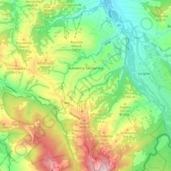
Naam: Topografische kaart Bukowina Tatrzańska, hoogte, reliëf.
Gemiddelde hoogte: 886 m
Minimale hoogte: 718 m
Maximale hoogte: 1.147 m
Andere topografische kaarten
Klik op een kaart om zijn topografie, zijn hoogte en zijn reliëf te bekijken.
Małe Ciche
Poland > Lesser Poland Voivodeship > Tatra County
Małe Ciche, gmina Poronin, Tatra County, Lesser Poland Voivodeship, Poland
Gemiddelde hoogte: 1.012 m
Stasindowie
Poland > Lesser Poland Voivodeship > Tatra County > Gliczarów Górny
Stasindowie, Gliczarów Górny, gmina Biały Dunajec, Tatra County, Lesser Poland Voivodeship, 34-531, Poland
Gemiddelde hoogte: 894 m
Zakopane
Poland > Lesser Poland Voivodeship > Tatra County
Zakopane, Tatra County, Lesser Poland Voivodeship, Poland
Gemiddelde hoogte: 1.199 m
Morskie Oko
Poland > Lesser Poland Voivodeship > Tatra County > Brzegi
Morskie Oko, Brzegi, gmina Bukowina Tatrzańska, Tatra County, Lesser Poland Voivodeship, Poland
Gemiddelde hoogte: 1.749 m
Białka Tatrzańska
Poland > Lesser Poland Voivodeship > Tatra County
Białka Tatrzańska, gmina Bukowina Tatrzańska, Tatra County, Lesser Poland Voivodeship, 34-405, Poland
Gemiddelde hoogte: 766 m
Kaniówka
Poland > Lesser Poland Voivodeship > Tatra County > Białka Tatrzańska
Kaniówka, Białka Tatrzańska, gmina Bukowina Tatrzańska, Tatra County, Lesser Poland Voivodeship, 34-405, Poland
Gemiddelde hoogte: 794 m
Tatry
Poland > Lesser Poland Voivodeship > Tatra County > Zakopane
Tatry, Zakopane, Tatra County, Lesser Poland Voivodeship, Poland
Gemiddelde hoogte: 1.647 m
Czarny Potok
Poland > Lesser Poland Voivodeship > Tatra County > Zakopane
Czarny Potok, Osiedle Kasprusie, Zakopane, Tatra County, Lesser Poland Voivodeship, 34-500, Poland
Gemiddelde hoogte: 869 m
Wielki Giewont
Poland > Lesser Poland Voivodeship > Tatra County > Zakopane
Wielki Giewont, Zakopane, Tatra County, Lesser Poland Voivodeship, Poland
Gemiddelde hoogte: 1.478 m
Zakopane
Poland > Lesser Poland Voivodeship > Tatra County
Zakopane, Tatra County, Lesser Poland Voivodeship, Poland
Gemiddelde hoogte: 1.180 m
Dzianisz
Poland > Lesser Poland Voivodeship > Tatra County > Dzianisz
Dzianisz, gmina Kościelisko, Tatra County, Lesser Poland Voivodeship, 34-514, Poland
Gemiddelde hoogte: 930 m
Biały Dunajec
Poland > Lesser Poland Voivodeship > Tatra County
Biały Dunajec, gmina Biały Dunajec, Tatra County, Lesser Poland Voivodeship, 34-425, Poland
Gemiddelde hoogte: 816 m
Jurgów
Poland > Lesser Poland Voivodeship > Tatra County
Jurgów, gmina Bukowina Tatrzańska, Tatra County, Lesser Poland Voivodeship, 34-532, Poland
Gemiddelde hoogte: 888 m