
Topografische kaart Village-Neuf
Interactieve kaart
Klik op de kaart om de hoogte weer te geven.
Over deze kaart
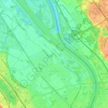
Naam: Topografische kaart Village-Neuf, hoogte, reliëf.
Gemiddelde hoogte: 248 m
Minimale hoogte: 232 m
Maximale hoogte: 272 m
Andere topografische kaarten
Klik op een kaart om zijn topografie, zijn hoogte en zijn reliëf te bekijken.
Pulvermuehle
France > Grand Est > Haut-Rhin > Volgelsheim
Pulvermuehle, Volgelsheim, Colmar-Ribeauvillé, Haut-Rhin, Grand Est, France métropolitaine, 68600, France
Gemiddelde hoogte: 192 m
Les Basses Huttes
France > Grand Est > Haut-Rhin > Orbey
Les Basses Huttes, Orbey, Colmar-Ribeauvillé, Haut-Rhin, Grand Est, France métropolitaine, 68370, France
Gemiddelde hoogte: 809 m
Kaysersberg
France > Grand Est > Haut-Rhin > Kaysersberg-Vignoble
Kaysersberg, Kaysersberg-Vignoble, Colmar-Ribeauvillé, Haut-Rhin, Grand Est, France métropolitaine, 68240, France
Gemiddelde hoogte: 523 m
Michelbach
France > Grand Est > Haut-Rhin > Aspach-Michelbach
Michelbach, Aspach-Michelbach, Thann-Guebwiller, Haut-Rhin, Grand Est, France métropolitaine, 68700, France
Gemiddelde hoogte: 338 m