
Topografische kaart Kilgarvan
Interactieve kaart
Klik op de kaart om de hoogte weer te geven.
Over deze kaart
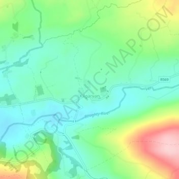
Naam: Topografische kaart Kilgarvan, hoogte, reliëf.
Gemiddelde hoogte: 71 m
Minimale hoogte: 12 m
Maximale hoogte: 200 m
Andere topografische kaarten
Klik op een kaart om zijn topografie, zijn hoogte en zijn reliëf te bekijken.
Tarbert
Tarbert, County Kerry, Munster, V31 WD66, Ireland
Gemiddelde hoogte: 22 m
Rathmore
Rathmore, Rathmore ED, Killarney Municipal District, County Kerry, Munster, P51 PT66, Ireland
Gemiddelde hoogte: 149 m
Murreagh
Murreagh, Kenmare Municipal District, County Kerry, Munster, V92 P681, Ireland
Gemiddelde hoogte: 37 m
Dooaghs
Dooaghs, Caragh ED, Kenmare Municipal District, County Kerry, Munster, Ireland
Gemiddelde hoogte: 10 m
Castlegregory
Castlegregory, Kenmare Municipal District, County Kerry, Munster, V92 F6NX, Ireland
Gemiddelde hoogte: 17 m
Fossa
Fossa, Killarney Rural ED, Killarney Municipal District, County Kerry, Munster, Ireland
Gemiddelde hoogte: 42 m
Beaufort
Beaufort, Dunloe ED, Kenmare Municipal District, County Kerry, Munster, Ireland
Gemiddelde hoogte: 38 m
Great Skellig
Great Skellig, Kenmare Municipal District, County Kerry, Munster, Ireland
Gemiddelde hoogte: 1 m
Stradbally Mountain
Stradbally Mountain, Kenmare Municipal District, County Kerry, Munster, Ireland
Gemiddelde hoogte: 487 m
Grenagh
Grenagh, Lahard ED, Killarney Municipal District, County Kerry, Munster, Ireland
Gemiddelde hoogte: 36 m
Killarney
Killarney, Killarney Municipal District, County Kerry, Munster, Ireland
Gemiddelde hoogte: 57 m
Kenmare Municipal District
Kenmare Municipal District, County Kerry, Munster, Ireland
Gemiddelde hoogte: 98 m
Spunkane
Spunkane, Emlagh ED, Kenmare Municipal District, County Kerry, Munster, V23 HP11, Ireland
Gemiddelde hoogte: 22 m
Glencloosagh Bay
Glencloosagh Bay, Tarbert ED, Listowel Municipal District, County Kerry, Munster, V31 WD66, Ireland
Gemiddelde hoogte: 12 m
Brandon Mountain
Brandon Mountain, Kenmare Municipal District, County Kerry, Munster, Ireland
Gemiddelde hoogte: 572 m
Dingle Peninsula
Dingle Peninsula, County Kerry, Munster, Ireland
Gemiddelde hoogte: 75 m
Knockanure
Knockanure, Listowel Municipal District, County Kerry, Munster, Ireland
Gemiddelde hoogte: 70 m
Carrauntoohil
Carrauntoohil, Kenmare Municipal District, County Kerry, Munster, V93 A8N1, Ireland
Gemiddelde hoogte: 644 m
Kenmare
Ireland > County Kerry > Kenmare
Kenmare, Kenmare Municipal District, County Kerry, Munster, V93 KDX0, Ireland
Gemiddelde hoogte: 87 m
Kilmorna
Kilmorna, Kilmeany ED, Listowel Municipal District, County Kerry, Munster, Ireland
Gemiddelde hoogte: 65 m
Kilkeaveragh
Kilkeaveragh, Portmagee ED, Kenmare Municipal District, County Kerry, Munster, Ireland
Gemiddelde hoogte: 38 m
Killorglin
Ireland > County Kerry > Killorglin
Killorglin, Kenmare Municipal District, County Kerry, Munster, V93 YD9D, Ireland
Gemiddelde hoogte: 24 m
Brick
Brick, Drommartin ED, Listowel Municipal District, County Kerry, Munster, Ireland
Gemiddelde hoogte: 4 m
Ardbeg
Ardbeg, Stradbally ED, Kenmare Municipal District, County Kerry, Munster, Ireland
Gemiddelde hoogte: 33 m
Finuge
Finuge, Ennismore ED, Listowel Municipal District, County Kerry, Munster, Ireland
Gemiddelde hoogte: 8 m
Rahoneen
Rahoneen, Banna ED, Tralee Municipal District, County Kerry, Munster, Ireland
Gemiddelde hoogte: 9 m
Scartaglin
Ireland > County Kerry > Scartaglin
Scartaglin, Tralee Municipal District, County Kerry, Munster, Ireland
Gemiddelde hoogte: 135 m
Rathmore
Ireland > County Kerry > Rathmore
Rathmore, Killarney Municipal District, County Kerry, Munster, Ireland
Gemiddelde hoogte: 154 m
Duagh
Duagh, Duagh ED, Listowel Municipal District, County Kerry, Munster, Ireland
Gemiddelde hoogte: 84 m
Dromclogh
Dromclogh, Ennismore ED, Listowel Municipal District, County Kerry, Munster, Ireland
Gemiddelde hoogte: 41 m
Ballyduff
Ireland > County Kerry > Ballyduff
Ballyduff, Listowel Municipal District, County Kerry, Munster, Ireland
Gemiddelde hoogte: 29 m
Killarney
Ireland > County Kerry > Killarney
Killarney, Killarney Municipal District, County Kerry, Munster, V93 AYP9, Ireland
Gemiddelde hoogte: 66 m
Tralee Municipal District
Tralee Municipal District, County Kerry, Munster, Ireland
Gemiddelde hoogte: 111 m
Dingle
Dingle, Kenmare Municipal District, County Kerry, Munster, Ireland
Gemiddelde hoogte: 121 m
Mangerton
Mangerton, Kenmare Municipal District, County Kerry, Munster, V93 T250, Ireland
Gemiddelde hoogte: 657 m