
Topografische kaart Santurtzi
Interactieve kaart
Klik op de kaart om de hoogte weer te geven.
Over deze kaart
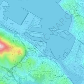
Naam: Topografische kaart Santurtzi, hoogte, reliëf.
Gemiddelde hoogte: 34 m
Minimale hoogte: -3 m
Maximale hoogte: 360 m
Santurtzi has a very rough orography although excluding Mount Serantes (452m) - one of its most symbolic topographic elements, it is not at high altitude, the significant heights being spurs of the Serantes (Serandi): The Mallet (245m) and the Fortified heights (123 and 106m). Its relief is within the north flank of the anticline of Biscay. It is a relief of a structural type corresponding to a series of materials of the Cretaceous period (limestone) throughout Punta Lucero-Serantes smoothly inclined towards the Estuary of Bilbao.