
Topografische kaart Hornby Lighthouse
Interactieve kaart
Klik op de kaart om de hoogte weer te geven.
Over deze kaart
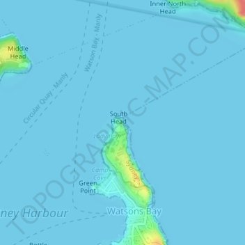
Naam: Topografische kaart Hornby Lighthouse, hoogte, reliëf.
Gemiddelde hoogte: 2 m
Minimale hoogte: 0 m
Maximale hoogte: 63 m
The wing for staff quarters in an "I" plan with enclosed verandahs either side. This building probably c. 1850s building having very good ashlar work to external walls with each elevation recessed within a frame of foundation, eaves and quoin mouldings. Windows are marked by simple classical sill and lintel mouldings. The hipped roofs originally of slate are now sheeted in asbestos cement. A good timber picket fence encloses the property which is in good condition and well maintained.
Andere topografische kaarten
Klik op een kaart om zijn topografie, zijn hoogte en zijn reliëf te bekijken.
Dangar Island
Dangar Island, Sydney, The Council of the Shire of Hornsby, 2083, Australia
Gemiddelde hoogte: 17 m
Carss Park
Australia > New South Wales > Sydney
Carss Park, St George, Sydney, Georges River Council, 2221, Australia
Gemiddelde hoogte: 15 m
Manly Lagoon
Australia > New South Wales > Sydney
Manly Lagoon, Rowe Street, Freshwater, Northern Beaches, Sydney, Northern Beaches Council, 2096, Australia
Gemiddelde hoogte: 23 m
Currency Creek
Currency Creek, Sydney, Hawkesbury City Council, 2756, Australia
Gemiddelde hoogte: 25 m
Sydney Water Supply Canal
Sydney Water Supply Canal, Sydney, Fairfield City Council, 2175, Australia
Gemiddelde hoogte: 82 m
Ropes Creek
Ropes Creek, Sydney, Fairfield City Council, 2175, Australia
Gemiddelde hoogte: 103 m
Callan Park
Callan Park, Lilyfield, Sydney, Inner West Council, 2040, Australia
Gemiddelde hoogte: 17 m
Badgerys Creek
Badgerys Creek, Sydney, Liverpool City Council, 2555, Australia
Gemiddelde hoogte: 79 m
Morrison Bay
Morrison Bay, Jetty Road, Putney, Sydney, Council of the City of Ryde, 2112, Australia
Gemiddelde hoogte: 18 m
Sydney Water Supply Canal
Sydney Water Supply Canal, Sydney, Campbelltown City Council, 2563, Australia
Gemiddelde hoogte: 110 m
Wynyard Park
Wynyard Park, Darling Quarter, Sydney, Council of the City of Sydney, 2000, Australia
Gemiddelde hoogte: 20 m
Russel Street Reserve
Russel Street Reserve, Strathfield, Sydney, Burwood Council, 2135, Australia
Gemiddelde hoogte: 25 m
Morreau reserve
Morreau reserve, Rooty Hill, Sydney, Blacktown City Council, 2766, Australia
Gemiddelde hoogte: 46 m
Sydney Water Supply Canal
Sydney Water Supply Canal, Sydney, Liverpool City Council, 2178, Australia
Gemiddelde hoogte: 74 m
Nepean River
Nepean River, Ambler Close, Emu Heights, Sydney, Penrith City Council, 2750, Australia
Gemiddelde hoogte: 61 m
Bold Park
Australia > New South Wales > Sydney
Bold Park, Cabramatta West, Sydney, Fairfield City Council, 2166, Australia
Gemiddelde hoogte: 33 m
Varroville
Australia > New South Wales > Sydney
Varroville, Sydney, Campbelltown City Council, 2566, Australia
Gemiddelde hoogte: 80 m
Carara Reserve
Australia > New South Wales > Sydney
Carara Reserve, West Ryde, Sydney, Council of the City of Ryde, 2114, Australia
Gemiddelde hoogte: 53 m
Silverwater
Australia > New South Wales > Sydney
Silverwater, Sydney, City of Parramatta Council, 2128, Australia
Gemiddelde hoogte: 10 m