
Doe een donatie
Rust jezelf uit voor je volgende avontuur:
Als Amazon-partner verdient deze site een commissie op in aanmerking komende aankopen, zonder extra kosten voor jou.
Topografische kaart Field
Klik op de kaart om de hoogte weer te geven.
Doe een donatie
Rust jezelf uit voor je volgende avontuur:
Als Amazon-partner verdient deze site een commissie op in aanmerking komende aankopen, zonder extra kosten voor jou.
Field
Field is an unincorporated community of approximately 169 people located in the Kicking Horse River valley of southeastern British Columbia, Canada, within the confines of Yoho National Park. At an elevation of 1,256 m (4,121 ft), it is 27 km (17 mi) west of Lake Louise along the Trans-Canada Highway, which provides the only road access to the town. The community is named for Cyrus West Field of Transatlantic telegraph cable fame, who visited the area in 1884.
Doe een donatie
Rust jezelf uit voor je volgende avontuur:
Als Amazon-partner verdient deze site een commissie op in aanmerking komende aankopen, zonder extra kosten voor jou.
Over deze kaart
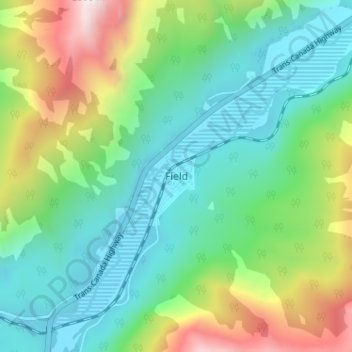
Naam: Topografische kaart Field, hoogte, reliëf.
Gemiddelde hoogte: 1.593 m
Minimale hoogte: 1.226 m
Maximale hoogte: 2.479 m
Doe een donatie
Rust jezelf uit voor je volgende avontuur:
Als Amazon-partner verdient deze site een commissie op in aanmerking komende aankopen, zonder extra kosten voor jou.
Andere topografische kaarten
Klik op een kaart om zijn topografie, zijn hoogte en zijn reliëf te bekijken.
Lake O'Hara
Canada > British Columbia > Columbia-Shuswap Regional District > Area A (Kicking Horse/Kinbasket Lake)
Lake O'Hara is a lake at an elevation of 2,020 metres (6,630 ft) in the alpine area of Yoho National Park, in the province of British Columbia, on the western side of the Great Divide with the province of Alberta and Banff National Park to the east. The lake and the valley are accessible through a bus service…
Gemiddelde hoogte: 2.276 m
Sherbrooke Lake
Canada > British Columbia > Columbia-Shuswap Regional District > Area A (Kicking Horse/Kinbasket Lake)
Gemiddelde hoogte: 2.080 m
Windy Arm
Canada > British Columbia > Columbia-Shuswap Regional District > Area A (Kicking Horse/Kinbasket Lake)
Gemiddelde hoogte: 1.009 m
Wapta Falls
Canada > British Columbia > Columbia-Shuswap Regional District > Area A (Kicking Horse/Kinbasket Lake)
Gemiddelde hoogte: 1.145 m
Doe een donatie
Rust jezelf uit voor je volgende avontuur:
Als Amazon-partner verdient deze site een commissie op in aanmerking komende aankopen, zonder extra kosten voor jou.
Quartz Creek
Canada > British Columbia > Columbia-Shuswap Regional District > Area A (Kicking Horse/Kinbasket Lake)
Gemiddelde hoogte: 1.352 m
Wapta Lake
Canada > British Columbia > Columbia-Shuswap Regional District > Area A (Kicking Horse/Kinbasket Lake)
Gemiddelde hoogte: 1.757 m
Takakkaw Lake
Canada > British Columbia > Columbia-Shuswap Regional District > Area A (Kicking Horse/Kinbasket Lake)
Gemiddelde hoogte: 2.143 m
Stanley Glacier
Canada > British Columbia > Columbia-Shuswap Regional District > Area A (Kicking Horse/Kinbasket Lake)
Gemiddelde hoogte: 2.488 m
Doe een donatie
Rust jezelf uit voor je volgende avontuur:
Als Amazon-partner verdient deze site een commissie op in aanmerking komende aankopen, zonder extra kosten voor jou.
Wapta Icefield
Canada > British Columbia > Columbia-Shuswap Regional District > Area A (Kicking Horse/Kinbasket Lake)
Gemiddelde hoogte: 2.564 m
Waputik Icefield
Canada > British Columbia > Columbia-Shuswap Regional District > Area A (Kicking Horse/Kinbasket Lake)
Gemiddelde hoogte: 2.432 m
Rogers Glacier
Canada > British Columbia > Columbia-Shuswap Regional District > Area A (Kicking Horse/Kinbasket Lake)
Gemiddelde hoogte: 2.499 m
Bugaboo Provincial Park
Canada > British Columbia > Columbia-Shuswap Regional District > Area A (Kicking Horse/Kinbasket Lake)
Gemiddelde hoogte: 2.192 m
Doe een donatie
Rust jezelf uit voor je volgende avontuur:
Als Amazon-partner verdient deze site een commissie op in aanmerking komende aankopen, zonder extra kosten voor jou.
Shackleton Glacier
Canada > British Columbia > Columbia-Shuswap Regional District > Area A (Kicking Horse/Kinbasket Lake)
Gemiddelde hoogte: 2.446 m
Forbes Glacier
Canada > British Columbia > Columbia-Shuswap Regional District > Area A (Kicking Horse/Kinbasket Lake)
Gemiddelde hoogte: 2.476 m
Emerald Lake
Canada > British Columbia > Columbia-Shuswap Regional District > Area A (Kicking Horse/Kinbasket Lake)
Many wild animals live in the area and are protected by Park Law, Brown (Grizzly) Bears and Black Bears are fairly common, they co-exist quite well with humans as the Park has strict laws on garbage control and good advice to Park Visitors on practicing bear safety and being "Bear Aware". Mountain Goats and…
Gemiddelde hoogte: 1.413 m
Lake O'Hara
Canada > British Columbia > Columbia-Shuswap Regional District > Area A (Kicking Horse/Kinbasket Lake)
Lake O'Hara is a lake at an elevation of 2,020 metres (6,630 ft) in the alpine area of Yoho National Park, in the province of British Columbia, on the western side of the Great Divide with the province of Alberta and Banff National Park to the east. The lake and the valley are accessible through a bus service…
Gemiddelde hoogte: 2.276 m
Doe een donatie
Rust jezelf uit voor je volgende avontuur:
Als Amazon-partner verdient deze site een commissie op in aanmerking komende aankopen, zonder extra kosten voor jou.
Emerald Lake
Canada > British Columbia > Columbia-Shuswap Regional District > Area A (Kicking Horse/Kinbasket Lake)
Many wild animals live in the area and are protected by Park Law, Brown (Grizzly) Bears and Black Bears are fairly common, they co-exist quite well with humans as the Park has strict laws on garbage control and good advice to Park Visitors on practicing bear safety and being "Bear Aware". Mountain Goats and…
Gemiddelde hoogte: 1.413 m
Harvey Bay
Canada > British Columbia > Columbia-Shuswap Regional District > Area A (Kicking Horse/Kinbasket Lake)
Gemiddelde hoogte: 977 m