Geolokaliseren

Topografische kaart Kingsbury

Interactieve kaart

Klik op de kaart om de hoogte weer te geven.

Over deze kaart

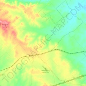
Naam: Topografische kaart Kingsbury, hoogte, reliëf.

Locatie: Kingsbury, Guadalupe County, Texas, United States (29.61551 -97.82282 29.70750 -97.74885)

Gemiddelde hoogte: 166 m

Minimale hoogte: 125 m

Maximale hoogte: 222 m

Andere topografische kaarten

Klik op een kaart om zijn topografie, zijn hoogte en zijn reliëf te bekijken.

Seguin

United States > Texas > Guadalupe County

Seguin, Guadalupe County, Texas, United States

Gemiddelde hoogte: 172 m

Cibolo

United States > Texas > Guadalupe County

Cibolo, Guadalupe County, Texas, 78108, United States

Gemiddelde hoogte: 220 m

Schertz

United States > Texas > Guadalupe County

Schertz, Guadalupe County, Texas, 78154, United States

Gemiddelde hoogte: 232 m

Zorn

United States > Texas > Guadalupe County

Zorn, Guadalupe County, Texas, United States

Gemiddelde hoogte: 169 m