
Topografische kaart Flint Hills Rodeo Grounds
Interactieve kaart
Klik op de kaart om de hoogte weer te geven.
Over deze kaart
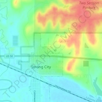
Naam: Topografische kaart Flint Hills Rodeo Grounds, hoogte, reliëf.
Gemiddelde hoogte: 380 m
Minimale hoogte: 356 m
Maximale hoogte: 421 m
Andere topografische kaarten
Klik op een kaart om zijn topografie, zijn hoogte en zijn reliëf te bekijken.
Strong City
United States > Kansas > Chase County > Strong City > Strong City
Strong City, Chase County, Kansas, 66869, United States
Gemiddelde hoogte: 381 m
Cottonwood Falls
United States > Kansas > Chase County > Cottonwood Falls > Cottonwood Falls
Cottonwood Falls, Chase County, Kansas, 66869, United States
Gemiddelde hoogte: 379 m
Elmdale
United States > Kansas > Chase County > Elmdale
Elmdale, Chase County, Kansas, 66850, United States
Gemiddelde hoogte: 369 m
Cottonwood Falls
United States > Kansas > Chase County
Cottonwood Falls, Chase County, Kansas, United States
Gemiddelde hoogte: 369 m
Strong City
United States > Kansas > Chase County
Strong City, Chase County, Kansas, 66869, United States
Gemiddelde hoogte: 370 m