
Topografische kaart Durango
Interactieve kaart
Klik op de kaart om de hoogte weer te geven.
Over deze kaart
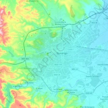
Naam: Topografische kaart Durango, hoogte, reliëf.
Locatie: Durango, Mexico (23.94563 -104.73078 24.09514 -104.51793)
Gemiddelde hoogte: 1.954 m
Minimale hoogte: 1.861 m
Maximale hoogte: 2.348 m
With 123,451.2 km2 or 12.3 million ha, Durango accounts for about 6.3% of the entire territory of Mexico. It is the fourth largest state lying at the extreme northwest of the Central Mexican Plateau, where it meets the Sierra Madre Occidental—the highest peaks in the state. The state has an average elevation of 1,775 meters above sea level, with a mean elevation of 1,750 m in the Valleys region and 2,450 m in the Sierra region. The city of Durango is on the foothills of the Sierra Madre Occidental, with an elevation of 1,857 m.