
Topografische kaart Peneda-Gerês National Park
Interactieve kaart
Klik op de kaart om de hoogte weer te geven.
Over deze kaart
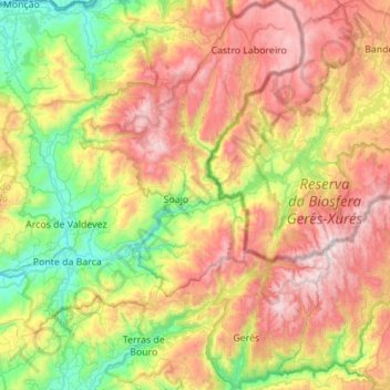
Naam: Topografische kaart Peneda-Gerês National Park, hoogte, reliëf.
Gemiddelde hoogte: 629 m
Minimale hoogte: 2 m
Maximale hoogte: 1.523 m
During the Pleistocene (approximately 1.8 to 0.001 Ma ago) climatic variations resulted in an extension of glacial fields to the mid-latitudes. While there are no remnants of glaciers now, their Ice Age products (U-shaped valleys, moraines, glacial deposits, polished and natural granite surfaces) are identified in the Serra da Peneda, Serra do Soajo and Serra do Gerês mountain ranges. The principal watersheds that cross the park are those of the Minho (occupying 2% of the park), Lima (47.8%) and Cávado (50.2%), with brooks and waterfalls common on many of the mountain slopes, in addition to several secondary tributaries (such as the Homem, Rabagão, Castro Laboreiro, and Arado rivers). The Lima cuts across the PNPG east to west, while the Cávado serves the southern limits of the districts of Vila Real and Braga. Fractures in the landscape have confined the rivers to deep, straight valleys and are visible in the younger granite outcrops visible in the uncovered higher altitudes. Owing to the number tributaries, the construction of hydroelectrical dams has been undertaken to generate electricity across six locations: Alto Rabagão, Paradela, Caniçada, Vilarinho da Furna, Touvedo and Lindoso.