
Topografische kaart Puerto Vallarta
Interactieve kaart
Klik op de kaart om de hoogte weer te geven.
Over deze kaart
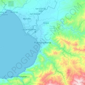
Naam: Topografische kaart Puerto Vallarta, hoogte, reliëf.
Gemiddelde hoogte: 306 m
Minimale hoogte: 0 m
Maximale hoogte: 1.881 m
Fourth: In 1968 the Puerto Vallarta municipality was elevated to City status. The elevation in status reflected interest by Mexican federal and state governments in developing the Puerto Vallarta as an international resort destination. Puerto Vallarta has since also attracted a lively immigrant community from the U.S., Canada and Europe.