
Topografische kaart Westminister
Interactieve kaart
Klik op de kaart om de hoogte weer te geven.
Over deze kaart
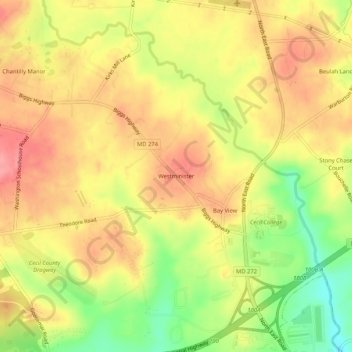
Naam: Topografische kaart Westminister, hoogte, reliëf.
Locatie: Westminister, Cecil County, Maryland, 21901, United States (39.62733 -75.98856 39.66733 -75.94856)
Gemiddelde hoogte: 99 m
Minimale hoogte: 43 m
Maximale hoogte: 137 m
Andere topografische kaarten
Klik op een kaart om zijn topografie, zijn hoogte en zijn reliëf te bekijken.
Cecil Manor
United States > Maryland > Cecil County
Cecil Manor, Cecil County, Maryland, 21920, United States
Gemiddelde hoogte: 44 m
Heritage Valley
United States > Maryland > Cecil County > Elkton
Heritage Valley, Elkton, Cecil County, Maryland, 21922, United States
Gemiddelde hoogte: 15 m
Perryville
United States > Maryland > Cecil County
Perryville, Cecil County, Maryland, 21903, United States
Gemiddelde hoogte: 46 m
Elkton
United States > Maryland > Cecil County
Elkton, Cecil County, Maryland, 21922, United States
Gemiddelde hoogte: 20 m
New Valley
United States > Maryland > Cecil County > New Valley
New Valley, Cecil County, Maryland, 21918, United States
Gemiddelde hoogte: 64 m