
Topografische kaart The Fort
Interactieve kaart
Klik op de kaart om de hoogte weer te geven.
Over deze kaart
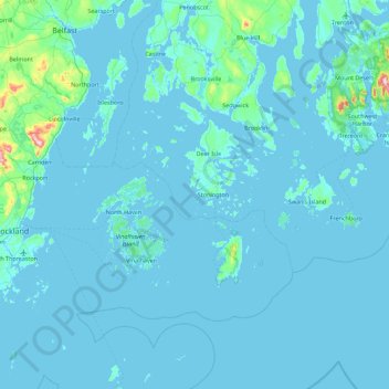
Naam: Topografische kaart The Fort, hoogte, reliëf.
Gemiddelde hoogte: 16 m
Minimale hoogte: -2 m
Maximale hoogte: 403 m
Andere topografische kaarten
Klik op een kaart om zijn topografie, zijn hoogte en zijn reliëf te bekijken.
Vinalhaven
United States of America > Maine > Vinalhaven
Vinalhaven, Knox County, Maine, 04863, United States of America
Gemiddelde hoogte: 11 m
Chebeague Island
United States of America > Maine > Chebeague Island
Chebeague Island, Cumberland County, Maine, 04017, United States of America
Gemiddelde hoogte: 9 m
Sand Island
United States of America > Maine
Sand Island, Aroostook County, Maine, United States of America
Gemiddelde hoogte: 159 m
Bar Harbor
United States of America > Maine > Bar Harbor
Bar Harbor, Hancock County, Maine, United States of America
Gemiddelde hoogte: 44 m
Byron
United States of America > Maine > Byron
Byron, Oxford County, Maine, United States of America
Gemiddelde hoogte: 397 m
Raymond Hill
United States of America > Maine
Raymond Hill, Cumberland County, Maine, 04071, United States of America
Gemiddelde hoogte: 167 m
Blue Hill
United States of America > Maine > Blue Hill
Blue Hill, Hancock County, Maine, 04614, United States of America
Gemiddelde hoogte: 55 m
Waltham
United States of America > Maine > Waltham
Waltham, Hancock County, Maine, United States of America
Gemiddelde hoogte: 66 m
Drakes Island
United States of America > Maine > Wells
Drakes Island, Wells, York County, Maine, United States of America
Gemiddelde hoogte: 40 m
Pretty Marsh
United States of America > Maine > Pretty Marsh
Pretty Marsh, Hancock County, Maine, 04674, United States of America
Gemiddelde hoogte: 22 m
East Poland
United States of America > Maine > East Poland
East Poland, Androscoggin County, Maine, United States of America
Gemiddelde hoogte: 87 m
Eggemoggin
United States of America > Maine > Eggemoggin
Eggemoggin, Hancock County, Maine, 04617, United States of America
Gemiddelde hoogte: 8 m
Washington
United States of America > Maine > Washington
Washington, Knox County, Maine, 04574, United States of America
Gemiddelde hoogte: 94 m
Fish Hill
United States of America > Maine
Fish Hill, Lincoln, Penobscot County, Maine, 04457, United States of America
Gemiddelde hoogte: 107 m
Bryants Corner
United States of America > Maine > Belfast > Bryants Corner
Bryants Corner, Belfast, Waldo County, Maine, 04915, United States of America
Gemiddelde hoogte: 47 m
Northern Island
United States of America > Maine
Northern Island, Knox County, Maine, United States of America
Gemiddelde hoogte: 3 m
Bangs Beach
United States of America > Maine > Bangs Beach
Bangs Beach, Kennebec County, Maine, United States of America
Gemiddelde hoogte: 92 m
Cedar
United States of America > Maine > Alexander > Cedar
Cedar, Alexander, Washington County, Maine, United States of America
Gemiddelde hoogte: 93 m
Ferry Village
United States of America > Maine > South Portland > Ferry Village
Ferry Village, South Portland, Cumberland County, Maine, 04101-4145, United States of America
Gemiddelde hoogte: 7 m
Sebasco
United States of America > Maine > Sebasco
Sebasco, Sagadahoc County, Maine, 04565, United States of America
Gemiddelde hoogte: 18 m
Stanley Hill
United States of America > Maine
Stanley Hill, Oxford County, Maine, United States of America
Gemiddelde hoogte: 121 m
Oak Island
United States of America > Maine
Oak Island, T4 Indian Purchase Township, Penobscot County, Maine, United States of America
Gemiddelde hoogte: 229 m