Topografische kaart Seguin
Interactieve kaart
Klik op de kaart om de hoogte weer te geven.
Over deze kaart
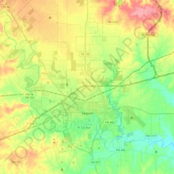
Naam: Topografische kaart Seguin, hoogte, reliëf.
Locatie: Seguin, Guadalupe County, Texas, United States (29.51199 -98.06061 29.68388 -97.83581)
Gemiddelde hoogte: 172 m
Minimale hoogte: 128 m
Maximale hoogte: 229 m
The elevation at the courthouse is 522 feet (159 m) above mean sea level.
Andere topografische kaarten
Klik op een kaart om zijn topografie, zijn hoogte en zijn reliëf te bekijken.
Cibolo
United States > Texas > Guadalupe County
Cibolo, Guadalupe County, Texas, 78108, United States
Gemiddelde hoogte: 220 m
Schertz
United States > Texas > Guadalupe County
Schertz, Guadalupe County, Texas, 78154, United States
Gemiddelde hoogte: 232 m
Zorn
United States > Texas > Guadalupe County
Zorn, Guadalupe County, Texas, United States
Gemiddelde hoogte: 169 m
Kingsbury
United States > Texas > Guadalupe County
Kingsbury, Guadalupe County, Texas, United States
Gemiddelde hoogte: 166 m