
Topografische kaart Paskenta
Interactieve kaart
Klik op de kaart om de hoogte weer te geven.
Over deze kaart
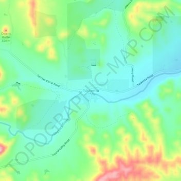
Naam: Topografische kaart Paskenta, hoogte, reliëf.
Locatie: Paskenta, Tehama County, California, 96074, United States (39.86429 -122.56697 39.90429 -122.52697)
Gemiddelde hoogte: 268 m
Minimale hoogte: 213 m
Maximale hoogte: 389 m
Paskenta (Wintun: Paskenti) is a small unincorporated town in Tehama County, California. Historically, it had greater local importance due to the presence of an active lumber mill. The ZIP Code is 96074. The community is inside area code 530 and the Paskenta CDP. Paskenta sits at an elevation of 725 feet (221 m). The 2010 United States census reported Paskenta's population was 112. Paskenta was originally inhabited by a tribe of Nomlaki people who are now part of the federally-recognized Paskenta Band of Nomlaki Indians.
Andere topografische kaarten
Klik op een kaart om zijn topografie, zijn hoogte en zijn reliëf te bekijken.
Manton
United States > California > Tehama County
Manton, Tehama County, California, United States
Gemiddelde hoogte: 722 m
Red Bluff
United States > California > Tehama County
Red Bluff, Tehama County, California, 96080, United States
Gemiddelde hoogte: 103 m
Manton
United States > California > Tehama County
Manton, Tehama County, California, United States
Gemiddelde hoogte: 722 m
Mineral
United States > California > Tehama County
Mineral, Tehama County, California, United States
Gemiddelde hoogte: 1.752 m
Rancho Tehama Reserve
United States > California > Tehama County
Rancho Tehama Reserve, Tehama County, CAL Fire Northern Region, California, United States
Gemiddelde hoogte: 237 m
Corning
United States > California > Tehama County
Corning, Tehama County, CAL Fire Northern Region, California, 96021, United States
Gemiddelde hoogte: 86 m
Paynes Creek
United States > California > Tehama County
Paynes Creek, Tehama County, California, United States
Gemiddelde hoogte: 143 m
Paynes Creek
United States > California > Tehama County > Dales
Paynes Creek, Dales, Tehama County, CAL Fire Northern Region, California, United States
Gemiddelde hoogte: 222 m
Los Molinos
United States > California > Tehama County > Los Molinos
Los Molinos, Tehama County, California, 96055, United States
Gemiddelde hoogte: 76 m