
Topografische kaart Governors Island
Interactieve kaart
Klik op de kaart om de hoogte weer te geven.
Over deze kaart
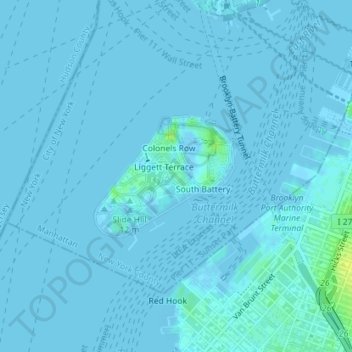
Naam: Topografische kaart Governors Island, hoogte, reliëf.
Gemiddelde hoogte: 1 m
Minimale hoogte: -3 m
Maximale hoogte: 16 m
Andere topografische kaarten
Klik op een kaart om zijn topografie, zijn hoogte en zijn reliëf te bekijken.
Harlem
USA > New York > New York City
Harlem, Manhattan, Manhattan Community Board 10, New York County, New York City, New York, USA
Gemiddelde hoogte: 16 m
Rikers Island
USA > New York > New York City
Rikers Island, Bronx County, New York City, New York, USA
Gemiddelde hoogte: 2 m
Chinatown
USA > New York > New York City
Chinatown, Manhattan, Manhattan Community Board 2, New York County, New York City, New York, USA
Gemiddelde hoogte: 12 m