
Topografische kaart Marshfield Hills
Interactieve kaart
Klik op de kaart om de hoogte weer te geven.
Over deze kaart
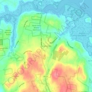
Naam: Topografische kaart Marshfield Hills, hoogte, reliëf.
Gemiddelde hoogte: 29 m
Minimale hoogte: -2 m
Maximale hoogte: 78 m
Andere topografische kaarten
Klik op een kaart om zijn topografie, zijn hoogte en zijn reliëf te bekijken.
Ocean Bluff
United States > Massachusetts > Plymouth County > Marshfield
Ocean Bluff, Marshfield, Plymouth County, Massachusetts, United States
Gemiddelde hoogte: 3 m
Kent Park
United States > Massachusetts > Plymouth County > Marshfield
Kent Park, Marshfield, Plymouth County, Massachusetts, 02050, United States
Gemiddelde hoogte: 13 m