
Topografische kaart Louisdale
Interactieve kaart
Klik op de kaart om de hoogte weer te geven.
Over deze kaart
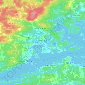
Naam: Topografische kaart Louisdale, hoogte, reliëf.
Gemiddelde hoogte: 26 m
Minimale hoogte: -4 m
Maximale hoogte: 112 m
Andere topografische kaarten
Klik op een kaart om zijn topografie, zijn hoogte en zijn reliëf te bekijken.
Battery Provincial Park
Canada > Nova Scotia > Municipality of the County of Richmond > St. Peter's
Battery Provincial Park, St. Peter's, Municipality of the County of Richmond, Richmond County, Nova Scotia, Canada
Gemiddelde hoogte: 9 m
Cap La Ronde
Canada > Nova Scotia > Municipality of the County of Richmond
Cap La Ronde, Municipality of the County of Richmond, Richmond County, Nova Scotia, Canada
Gemiddelde hoogte: 2 m
Potato Island
Canada > Nova Scotia > Municipality of the County of Richmond > Poirierville
Potato Island, Poirierville, Municipality of the County of Richmond, Richmond County, Nova Scotia, Canada
Gemiddelde hoogte: 4 m
Thorn Creek
Canada > Nova Scotia > Municipality of the County of Richmond > Glasgow Point
Thorn Creek, Glasgow Point, Municipality of the County of Richmond, Richmond County, Nova Scotia, Canada
Gemiddelde hoogte: 4 m
St. Peters Inlet
Canada > Nova Scotia > Municipality of the County of Richmond > Barra Head
St. Peters Inlet, Chapel Island 5, Barra Head, Municipality of the County of Richmond, Richmond County, Nova Scotia, Canada
Gemiddelde hoogte: 17 m
Berry Island
Canada > Nova Scotia > Municipality of the County of Richmond > Martinique
Berry Island, Martinique, Municipality of the County of Richmond, Richmond County, Nova Scotia, B0E 1V0, Canada
Gemiddelde hoogte: 41 m