
Topografische kaart Siruguppa
Interactieve kaart
Klik op de kaart om de hoogte weer te geven.
Over deze kaart
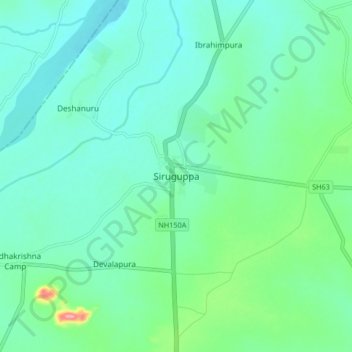
Naam: Topografische kaart Siruguppa, hoogte, reliëf.
Gemiddelde hoogte: 372 m
Minimale hoogte: 346 m
Maximale hoogte: 470 m
Siruguppa is located at 15°38′N 76°54′E / 15.63°N 76.9°E / 15.63; 76.9. Located on the Deccan plateau, it has an average elevation of 373 metres (1223 feet). It belongs to the dry inland region of Karnataka with an annual rainfall of 645 mm. The Taluk is bounded in the south by Bellary taluk, in the west by Hospet taluk, in the north by Sindhanur taluk of Raichur district and in the east by Adoni taluk of Kurnool district of Andhra Pradesh.
Andere topografische kaarten
Klik op een kaart om zijn topografie, zijn hoogte en zijn reliëf te bekijken.
Konchigeri
India > Karnataka > Siruguppa taluku
Konchigeri, Siruguppa taluku, Ballari District, Karnataka, 583120, India
Gemiddelde hoogte: 421 m
Karchiganuru
India > Karnataka > Siruguppa taluku
Karchiganuru, Siruguppa taluku, Ballari District, Karnataka, India
Gemiddelde hoogte: 366 m