
Topografische kaart Pine Bluff
Interactieve kaart
Klik op de kaart om de hoogte weer te geven.
Pine Bluff
The city is situated in the Southeast section of the Arkansas Delta and straddles the Arkansas Timberlands region to its west. Its topography is flat with wide expanses of farmland, similar to other places in the Delta Lowlands. Pine Bluff has numerous creeks, streams, and bayous, including Bayou Bartholomew, the longest bayou in the world and the second most ecologically diverse stream in the United States. Large bodies of water include Lake Pine Bluff, Lake Langhofer (Slack Water Harbor), and the Arkansas River.
Over deze kaart
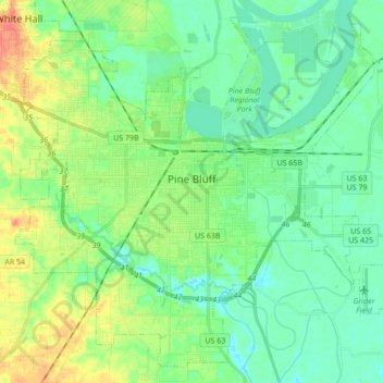
Naam: Topografische kaart Pine Bluff, hoogte, reliëf.
Locatie: Pine Bluff, Jefferson County, Arkansas, United States (34.14586 -92.09322 34.27595 -91.92123)
Gemiddelde hoogte: 69 m
Minimale hoogte: 54 m
Maximale hoogte: 100 m
Andere topografische kaarten
Klik op een kaart om zijn topografie, zijn hoogte en zijn reliëf te bekijken.