
Topografische kaart Rakaia Gorge lookout
Interactieve kaart
Klik op de kaart om de hoogte weer te geven.
Over deze kaart
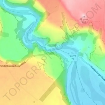
Naam: Topografische kaart Rakaia Gorge lookout, hoogte, reliëf.
Gemiddelde hoogte: 358 m
Minimale hoogte: 269 m
Maximale hoogte: 484 m
Andere topografische kaarten
Klik op een kaart om zijn topografie, zijn hoogte en zijn reliëf te bekijken.
Ōtūroto / Lake Heron
New Zealand > Canterbury > Ashburton District
Ōtūroto / Lake Heron, Ashburton District, Canterbury, New Zealand
Gemiddelde hoogte: 750 m
Ashburton
New Zealand > Canterbury > Ashburton District
Ashburton, Ashburton District, Canterbury, 7700, New Zealand
Gemiddelde hoogte: 99 m
Totara Peak
New Zealand > Canterbury > Ashburton District
Totara Peak, Ashburton District, Canterbury, New Zealand
Gemiddelde hoogte: 1.645 m
Dromore
New Zealand > Canterbury > Ashburton District
Dromore, Ashburton District, Canterbury, 7772, New Zealand
Gemiddelde hoogte: 123 m
Methven
New Zealand > Canterbury > Ashburton District
Methven, Ashburton District, Canterbury, 7730, New Zealand
Gemiddelde hoogte: 322 m
Hackthorne
New Zealand > Canterbury > Ashburton District
Hackthorne, Ashburton District, Canterbury, New Zealand
Gemiddelde hoogte: 199 m
Mayfield
New Zealand > Canterbury > Ashburton District
Mayfield, Ashburton District, Canterbury, 7778, New Zealand
Gemiddelde hoogte: 266 m
Ashburton Lakes
New Zealand > Canterbury > Ashburton District
Ashburton Lakes, Ashburton District, Canterbury, New Zealand
Gemiddelde hoogte: 645 m
Ruapuna
New Zealand > Canterbury > Ashburton District
Ruapuna, Ashburton District, Canterbury, New Zealand
Gemiddelde hoogte: 302 m
Mount Somers
New Zealand > Canterbury > Ashburton District
Mount Somers, Ashburton District, Canterbury, New Zealand
Gemiddelde hoogte: 1.221 m
Lake Clearwater
New Zealand > Canterbury > Ashburton District
Lake Clearwater, Ashburton District, Canterbury, New Zealand
Gemiddelde hoogte: 751 m